7 Features to Look for in Water Activity Weather Apps That Pros Trust
Discover 7 essential features that separate basic weather apps from advanced marine forecasting tools for safer water activities like kayaking and boating.
The big picture: You’re planning your next kayaking trip or beach day, but unpredictable weather can turn your water adventure into a dangerous situation. Standard weather apps often miss the specialized marine conditions that matter most for water activities â like wind patterns, wave heights, and water temperature changes.
Why it matters: The right water activity weather app can mean the difference between a perfect day on the water and a costly rescue operation. These specialized tools provide crucial data that general weather services simply don’t offer, helping you make informed decisions about when to launch and when to stay ashore.
What’s ahead: We’ll break down seven essential features that separate basic weather apps from the comprehensive marine forecasting tools serious water enthusiasts rely on daily.
Disclosure: As an Amazon Associate, this site earns from qualifying purchases. Thank you!
Real-Time Weather Data and Accurate Forecasting
Your safety on the water depends on having the most current conditions at your fingertips. Marine weather changes faster than terrestrial forecasts, making real-time data your first line of defense against dangerous situations.
Live Weather Updates Every 15 Minutes
Standard weather apps update hourly, but water conditions change by the minute. You’ll want apps that pull data from marine buoys and coastal stations every 15 minutes or less. This frequency catches sudden wind shifts that can turn a calm paddle into a struggle against whitecaps, or temperature drops that signal incoming storms.
Extended 7-Day Marine Forecasts
Seven-day marine forecasts reveal patterns that weekend warriors miss. While tomorrow’s conditions matter most, extended forecasts show you approaching high-pressure systems that create perfect water days. You’ll spot multi-day weather windows for longer trips and avoid planning around false calm periods before major storm systems arrive.
Radar and Satellite Imagery Integration
Live radar shows you what’s coming before you feel it. The best water activity apps overlay precipitation, wind patterns, and cloud formations on interactive maps. You can track storm cells moving toward your launch point and watch wind direction changes that affect wave formation and water temperature mixing.
Wind Speed and Direction Analysis
Wind patterns can make or break your time on the water. Professional marine weather apps deliver precise wind analysis that standard apps simply can’t match.
Detailed Wind Pattern Tracking
Quality apps display wind vectors with directional arrows and speed gradients across your specific water body. You’ll see how wind flows around islands, channels, and shorelines rather than generic regional data. This localized tracking reveals wind shadows and acceleration zones that directly impact your activity planning.
Gust Predictions and Alerts
Advanced apps predict wind gusts 2-4 hours ahead with customizable alert thresholds. You’ll receive notifications when sustained winds or gusts exceed your preset limits – typically 15 mph for paddling or 25 mph for sailing. These alerts prevent you from launching into deteriorating conditions or getting caught off-guard mid-activity.
Historical Wind Data Comparison
Top-tier apps overlay current conditions against historical averages for your location and season. You’ll understand whether today’s 12 mph northeast wind is typical for March or unusually strong. This comparison helps you gauge normal patterns and identify when conditions deviate significantly from seasonal norms.
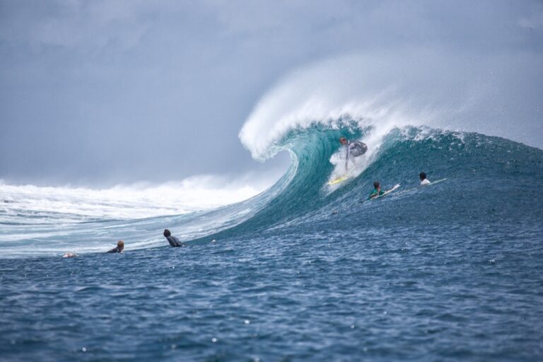
Wave Height and Swell Information
Understanding wave patterns makes the difference between an epic day on the water and a dangerous situation. Professional marine weather apps deliver critical wave data that standard weather services simply can’t match.
Current Wave Conditions Display
Live wave height readings show you exactly what you’re facing before you launch. Quality apps display wave heights in real-time with visual indicators showing whether conditions are building or calming. You’ll see significant wave height, maximum wave height, and wave period data that updates every 15 minutes from offshore buoys and coastal monitoring stations.
Surf Forecast and Swell Direction
Swell direction predictions reveal which beaches will have the cleanest conditions. Advanced apps show multiple swell trains approaching your area with directional arrows and timing forecasts. You can track long-period swells from distant storms and short-period wind waves that create choppy conditions, helping you choose protected launch sites.
Tide Charts and Water Level Data
Accurate tide information determines safe access points and optimal timing for your activities. Marine apps integrate detailed tide charts showing high/low times, tidal range, and current flow directions. You’ll avoid getting stranded on sandbars during dropping tides and can time your departure to ride favorable currents back to shore.
Marine Weather Alerts and Warnings
Real-time weather alerts can save your life on the water. The best marine weather apps deliver critical warnings directly to your device, cutting through the noise of general weather notifications.
Severe Weather Notifications
Advanced marine apps send push notifications for thunderstorms, waterspouts, and high wind warnings specific to your water body. You’ll receive alerts 30-60 minutes before severe conditions hit your location. These targeted warnings beat general weather alerts because they account for how storms move differently over water versus land.
Small Craft Advisory Systems
Quality apps automatically display small craft advisories when wind speeds exceed 25 knots or wave heights reach unsafe levels for your vessel type. You can customize thresholds based on your boat size and experience level. The system flags dangerous conditions before you launch, preventing you from getting caught in deteriorating weather.
Lightning Strike Detection
Top-tier marine weather apps track real-time lightning strikes within a 50-mile radius of your position. The detection system shows strike frequency and movement patterns, helping you determine whether storms are approaching or moving away. You’ll know exactly when it’s safe to return to the water after electrical activity passes.
UV Index and Sun Protection Guidance
Stay protected from the sun with Neutrogena Ultra Sheer SPF 70 Sunscreen. Lightweight, non-greasy, and water-resistant formula.

Water activities double your UV exposure through reflected sunlight off the water’s surface. Quality marine weather apps track hourly UV levels and provide personalized sun protection recommendations based on your skin type and planned activities.
Hourly UV Level Tracking
Advanced marine apps display real-time UV index readings that update throughout the day, showing you exactly when radiation peaks at your water location. You’ll see numerical UV values from 1-11+ with color-coded warnings that help you time your sun exposure safely. This hourly tracking reveals how UV intensity changes with cloud cover and sun angle, letting you adjust protection strategies as conditions shift.
Sunburn Risk Assessment
Top-tier water activity apps calculate your personal sunburn risk by combining current UV levels with your skin type and planned exposure time. You’ll receive specific warnings like “moderate risk – sunburn possible in 20 minutes” based on real-time conditions at your exact location. These personalized assessments account for water reflection, which can increase UV exposure by 10-15% compared to land-based activities.
Peak Sun Exposure Times
Professional marine apps pinpoint daily peak UV hours for your specific water body, typically showing maximum intensity between 10 AM and 2 PM. You’ll see when UV levels exceed safe thresholds for extended water activities, helping you plan breaks or adjust your schedule accordingly. These apps factor in seasonal variations and geographic location to provide precise timing recommendations for your area’s unique sun patterns.
Water Temperature Monitoring
Water temperature monitoring transforms your activity planning from guesswork into informed decision-making. Professional marine weather apps deliver precise temperature data that affects everything from wetsuit selection to safety protocols.
Current Surface Temperature Readings
Current Surface Temperature Readings provide real-time water conditions updated every 30 minutes from offshore buoys and coastal monitoring stations. Quality marine apps display temperature variations across different areas of your water body, revealing thermal differences between shallow bays and deeper channels. You’ll spot temperature drops that signal upwelling events or cold water intrusions that can catch swimmers off guard.
Seasonal Temperature Trends
Seasonal Temperature Trends help you understand whether current water temperatures are typical for the time of year or unusually warm or cold. Advanced apps compare today’s readings against 10-year historical averages, showing temperature departure data that reveals early or late seasonal transitions. You’ll identify optimal timing for activities like surfing or swimming when water temperatures peak above normal ranges.
Thermal Layer Information
Thermal Layer Information reveals temperature stratification in deeper waters that affects diving conditions and fish behavior. Professional apps display thermocline depth data showing where warm surface water meets cooler depths, typically occurring 15-40 feet down in lakes and coastal areas. You’ll understand how thermal layers impact underwater visibility and plan dive profiles around temperature boundaries that create distinct water zones.
Location-Based Customization Features
Advanced marine weather apps recognize that conditions vary dramatically across water bodies, delivering hyper-local forecasts that generic apps simply can’t match.
GPS-Enabled Spot Forecasts
GPS-enabled spot forecasts transform your smartphone into a precision weather station for your exact location. Quality marine apps analyze conditions within a 0.5-mile radius of your coordinates, revealing microclimate variations that can make or break your water activities. You’ll receive targeted data for your specific cove, inlet, or launch point rather than broad regional forecasts that miss critical local conditions.
Track your home weather with the Ambient Weather WS-2902. This WiFi-enabled station measures wind, rain, temperature, and more, sending data to your smart home via IFTTT, Alexa, and Google Home.

Multiple Location Bookmarking
Multiple location bookmarking lets you save and monitor up to 20 favorite water spots simultaneously across different regions. Professional apps display comparative weather data for all saved locations, helping you choose the best destination for current conditions. You can track seasonal patterns at each bookmarked spot, building a personal database of optimal timing for different activities throughout the year.
Offline Data Access Capabilities
Offline data access capabilities ensure you maintain weather information even when cellular coverage disappears on remote waters. Top-tier marine apps download 48-72 hours of forecast data directly to your device, including radar imagery and hourly updates. You’ll access critical safety information like storm warnings and wind alerts without depending on spotty marine internet connections that often fail when you need them most.
Conclusion
Your safety on the water depends on having the right weather information at your fingertips. These seven features transform your phone into a powerful marine forecasting tool that can prevent dangerous situations and enhance your water activities.
Don’t compromise on quality when choosing a marine weather app. The difference between basic weather data and professional-grade marine forecasting could be the difference between a perfect day on the water and an emergency rescue situation.
Take time to test different apps and find one that offers the specific features you need for your favorite water activities. Your preparation today ensures countless safe and enjoyable adventures on the water tomorrow.
Frequently Asked Questions
Why are specialized weather apps better than standard weather apps for water activities?
Specialized marine weather apps provide critical information that standard apps lack, including real-time wind patterns, wave heights, water temperature, and tide data. They update every 15 minutes compared to hourly updates from standard apps, giving water enthusiasts the precise, location-specific forecasts needed for safety and planning on unpredictable marine environments.
What are the key features that distinguish basic weather apps from advanced marine forecasting tools?
Advanced marine apps offer seven key features: real-time weather data with 15-minute updates, extended 7-day marine forecasts, integrated radar and satellite imagery, precise wind speed and direction analysis, wave height and swell information, real-time weather alerts and warnings, and location-based customization with GPS-enabled spot forecasts.
How often do marine weather apps update their data compared to standard weather apps?
Marine weather apps provide live updates every 15 minutes, while standard weather apps typically update hourly. This frequent updating is crucial for water activities since marine weather conditions can change rapidly, allowing users to respond quickly to sudden weather shifts and maintain safety on the water.
What wind information do professional marine weather apps provide?
Professional marine apps display localized wind patterns with directional arrows and speed gradients, reveal wind shadows and acceleration zones, provide gust predictions and alerts when conditions exceed preset limits, and offer historical wind data comparison to help users assess whether current conditions are typical or unusually strong for the season.
Why is wave height and swell information important for water activities?
Wave height and swell data help distinguish between safe and dangerous water conditions. Professional apps provide real-time wave height readings, wave period data from offshore buoys, surf forecasts with swell direction tracking, and information about multiple swell trains to help users identify optimal beach conditions and timing.
How do marine weather apps help with safety alerts and warnings?
Advanced marine apps deliver targeted notifications for severe weather 30-60 minutes in advance, display small craft advisories based on vessel type and experience level, track real-time lightning strikes within a 50-mile radius, and provide customized weather thresholds to help users determine when conditions become unsafe for their specific activities.
What UV protection features do quality marine weather apps offer?
Marine weather apps provide hourly UV level updates, personalized sun protection recommendations based on skin type, real-time UV index readings that account for water reflection doubling exposure, sunburn risk assessments, and identification of peak sun exposure times to help users plan safe water activities.
How do marine apps help with water temperature monitoring?
Professional marine apps deliver current surface temperature readings updated every 30 minutes, reveal thermal differences across water areas, provide seasonal temperature trends compared to historical averages, and offer thermal layer information that impacts diving conditions and marine life behavior for better activity planning.
What location-based features do advanced marine weather apps provide?
Advanced apps offer GPS-enabled spot forecasts for exact locations, multiple location bookmarking to track up to 20 favorite water spots simultaneously, hyper-local forecasts that generic apps cannot match, and offline data access capabilities to ensure critical weather information is available even without cellular coverage.