6 Best Touring Paddleboard Navigation Devices For Experts
Navigate your next expedition with precision. We review the top 6 touring paddleboard GPS devices, focusing on reliability, mapping, and expert-level features.
When you are miles from the shoreline with nothing but the horizon ahead, your navigation gear becomes your most critical piece of safety equipment. Touring paddleboarding demands more than just a sense of direction; it requires precision, durability, and reliable communication. These six devices represent the gold standard for experts who refuse to compromise on their backcountry safety.
Disclosure: As an Amazon Associate, this site earns from qualifying purchases. Thank you!
Garmin GPSMAP 67i: Best for Global Expedition Use

If your expeditions take you into remote coastal waters where cell service is a distant memory, the GPSMAP 67i is your ultimate insurance policy. This handheld device combines multi-band GNSS technology with inReach satellite communication, allowing you to send messages and trigger SOS alerts from anywhere on the planet. Its rugged, waterproof construction is built to withstand the constant splash and salt exposure inherent to long-distance touring.
For the expert paddler, the primary advantage here is the dedicated screen real estate and physical button interface, which are far easier to manage with wet, cold hands than a touchscreen. While it is bulkier than a watch, the ability to view detailed topographic maps on a high-contrast display provides a level of situational awareness that smaller devices simply cannot match. If you are planning multi-day self-supported crossings, this is the device that keeps you connected and on course.
Garmin Instinct 2 Solar: Best Wrist-Based Device
The Garmin Instinct 2 Solar extends your adventures with unlimited battery life in smartwatch mode via solar charging. Track activities with built-in sports apps, GPS, and health monitoring, all in a rugged, water-resistant design.

The Instinct 2 Solar is the workhorse of the paddleboarding world, favored for its "set it and forget it" reliability. Its standout feature is the solar charging capability, which significantly extends battery life during long days on the water. The monochrome display is exceptionally crisp, remaining perfectly readable even under the harsh glare of midday sun reflecting off the water.
This device is for the minimalist who wants comprehensive tracking without the distraction of a complex smartwatch. It offers robust GPS tracking, tide data, and water-resistant durability that handles submersion without a second thought. If you prioritize long-term battery performance and a rugged, no-nonsense interface, the Instinct 2 Solar is the most practical companion for your touring kit.
Suunto Race S: Best for Advanced Data Analytics

For the data-driven paddler who treats every tour as a training session, the Suunto Race S offers unparalleled analytical depth. Its AMOLED display is stunning, providing high-resolution maps that make navigating complex estuaries or intricate island chains intuitive and clear. The device excels at breaking down your stroke efficiency, heart rate variability, and exertion levels in real-time.
Where this device truly shines is in its post-trip analysis, allowing you to sync your data with advanced platforms to optimize your touring performance. It is an ideal choice for the expert who wants to understand the physiological toll of their long-distance efforts while maintaining precise navigation. If you view your paddleboard tours as a blend of exploration and athletic optimization, the Race S is your best bet.
Coros Vertix 2: Best Battery Life for Long Trips

When you are out for days at a time without access to a power bank, the Coros Vertix 2 is in a league of its own. It boasts an immense battery life that can track your location for over a week of continuous use, even in high-accuracy GPS modes. Its build quality is equally impressive, featuring a titanium frame and sapphire glass that can handle the inevitable bumps against a carbon fiber paddle or rocky shoreline.
The interface is designed for efficiency, using a large digital dial that is easy to manipulate even while wearing neoprene gloves. It offers dual-frequency GPS, which is a major advantage when paddling through canyons or near high cliffs where signal reflection can confuse lesser devices. If your priority is absolute longevity and durability in the harshest environments, the Vertix 2 is the clear winner.
Apple Watch Ultra 2: Best Integrated Smart Device
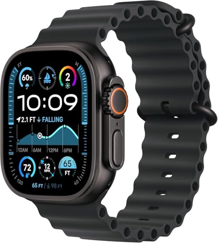
The Apple Watch Ultra 2 is a powerhouse for the paddler who wants a seamless transition from the office to the open water. Its deep integration with the Apple ecosystem means you have access to tide apps, weather alerts, and emergency communication features that are incredibly user-friendly. The high-brightness display is arguably the best in the industry, ensuring your maps are visible even in direct, blinding sunlight.
While it lacks the multi-day battery life of dedicated expedition units, its "smart" features—such as integrated cellular connectivity and advanced emergency sirens—make it a top-tier safety tool for coastal touring. It is perfect for those who want a high-performance navigation device that also serves as their daily driver. If you stay within reach of cellular networks and value a polished user experience, this is the device to choose.
Wahoo Elemnt Roam V2: Best for Precision Mapping

While typically found on handlebars, the Wahoo Elemnt Roam V2 is a secret weapon for paddlers who mount it to their deck rigging. Its mapping capabilities are industry-leading, featuring a "Smart Navigation" function that can reroute you instantly if you drift off your planned course. The screen is designed to be glare-free, and the LED indicators provide at-a-glance navigation cues without requiring you to stare at a map.
This device is for the paddler who demands accurate, turn-by-turn navigation in complex waterways. By mounting it to your board, you keep your hands free for paddling while maintaining a constant, clear view of your route and upcoming hazards. If you are navigating around busy shipping lanes or complex coastal geography, the Elemnt Roam V2 provides the precision you need to stay safe.
Essential Navigation Features for Touring Boards
When selecting a device, you must prioritize multi-band GNSS, which uses multiple satellite frequencies to provide pinpoint accuracy even in challenging conditions. Look for devices that offer offline map storage, as you cannot rely on cellular data or Wi-Fi when you are miles offshore. A high-contrast, sunlight-readable display is non-negotiable; if you can’t read your map at noon, it is effectively useless.
Furthermore, consider the physical interface. Touchscreens can be notoriously difficult to use with wet fingers or gloves, making physical buttons or a tactile dial a much safer option for marine environments. Always ensure your device has a dedicated "breadcrumb" feature, which records your path so you can easily backtrack if weather conditions deteriorate or visibility drops.
Understanding Satellite Connectivity and Safety
Satellite connectivity is the difference between a minor mishap and a major rescue operation. Devices with two-way communication, like those with inReach or cellular-integrated SOS, allow you to send your coordinates and status to emergency services or family members. Do not confuse standard GPS tracking with satellite communication; one tells you where you are, the other tells the world you need help.
When heading into remote areas, test your device’s emergency protocols before you leave the shore. Ensure your contacts are updated, your subscription is active, and you understand the delay involved in satellite messaging. Remember that satellite signals can be blocked by steep terrain, so always maintain a clear view of the sky whenever possible.
Integrating Digital Maps With Physical Charts
Even with the most advanced GPS, never head out on a long-distance tour without a physical chart or a waterproof map of your area. Digital devices are prone to battery failure, screen damage, and software glitches, especially when exposed to saltwater and extreme temperatures. A physical chart provides a permanent, reliable reference that requires no power to function.
Use your digital device for real-time tracking and course corrections, but cross-reference your position with your paper chart at regular intervals. This practice builds "dead reckoning" skills, ensuring that you can still navigate if your tech fails. Treating your digital device as a supplement to—not a replacement for—traditional navigation is the hallmark of an experienced, responsible paddler.
Maintaining Your Device in Marine Environments
Saltwater is the enemy of all electronics, and even "waterproof" devices will degrade if not properly maintained. After every session, rinse your device thoroughly with fresh water to remove salt crystals that can corrode charging ports and buttons. Avoid using high-pressure spray, which can force water past seals that are designed to withstand immersion, not direct impact.
Periodically inspect your charging cables and ports for signs of oxidation or buildup. If you use a deck-mounted device, ensure the mount is secure and inspect the hardware for rust or loosening due to vibration. Storing your device in a cool, dry place away from direct sunlight when not in use will significantly extend the lifespan of your battery and display.
Navigating the open water is a skill that blends technology with intuition and preparation. While these devices provide incredible support, your best navigation tool remains your own situational awareness and respect for the environment. Choose the gear that fits your specific touring style, maintain it with care, and always keep your eyes on the horizon.