6 Best Boat Navigation Gps Units For Accuracy For Sailors
Navigate with confidence using our top 6 GPS units. Discover high-accuracy marine systems designed to keep sailors safe, precise, and on course at all times.
Navigating open water requires more than just a compass; it demands the unwavering precision of a high-end GPS unit to keep your vessel on track. Whether you are coastal cruising or planning an offshore passage, having reliable coordinates is the difference between a smooth journey and a navigational headache. This guide breaks down the top units available today to ensure your next voyage is as accurate as it is enjoyable.
Disclosure: As an Amazon Associate, this site earns from qualifying purchases. Thank you!
Garmin GPSMAP 86sci: Best For Reliable Tracking
Navigate confidently with the GPSMAP 86i. This water-resistant handheld features preloaded BlueChart g3 coastal charts, and offers global two-way messaging and SOS capabilities via satellite subscription.

If you are a sailor who values redundancy and ruggedness, the Garmin GPSMAP 86sci is your ultimate handheld companion. It integrates seamlessly with your boat’s onboard systems while providing a robust, waterproof backup that works even if your main power fails.
This unit is ideal for those who spend time in remote areas where satellite connectivity is non-negotiable. Its inReach technology allows for two-way messaging and SOS capabilities, providing an essential safety net when you are far from shore. If you want a device that can survive a dunking and still guide you home, this is the one to carry.
B&G Zeus3S Chartplotter: Elite Sailing Precision
B&G is built specifically for sailors, and the Zeus3S is the gold standard for those who demand performance in a tactical environment. It features dedicated sailing software that calculates laylines, weather routing, and start-line data with professional-grade accuracy.
The processing speed on the Zeus3S is incredibly fast, meaning your charts redraw instantly as you zoom in or change course. If you are a competitive racer or a dedicated cruiser who wants to optimize every tack, this unit is a mandatory upgrade. It is a specialized tool that turns complex data into actionable sailing insights.
Simrad GO9 XSE: Best Intuitive Touchscreen Unit

For sailors who find complex menus frustrating, the Simrad GO9 XSE offers a smartphone-like interface that makes navigation effortless. It is a fantastic all-in-one solution that balances ease of use with powerful sonar and GPS capabilities.
This unit is the perfect choice for someone upgrading an older boat who wants modern features without a steep learning curve. The intuitive touchscreen allows you to drag, drop, and pinch-zoom through your charts just like you would on a tablet. If you prioritize simplicity and a clean helm aesthetic, you will love this system.
Raymarine Axiom 9: Top Choice For Clear Imaging

The Raymarine Axiom 9 stands out for its high-performance processor and stunningly clear display. It renders charts in incredible detail, allowing you to identify shallow hazards or channel markers at a glance, even in bright, direct sunlight.
This unit is built for the modern captain who wants to integrate radar, thermal cameras, and AIS into one cohesive system. Its LightHouse operating system is remarkably fluid, making it a joy to use during long watches. If you want a display that provides the best visual clarity on the market, the Axiom 9 is your best bet.
Lowrance Elite FS 9: Best For Coastal Navigation
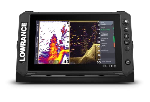
While Lowrance is often associated with fishing, the Elite FS 9 is a hidden gem for coastal sailors who need high-resolution mapping on a budget. It provides excellent GPS accuracy and easy networking capabilities, making it a versatile choice for smaller to mid-sized sailboats.
The unit excels at displaying detailed cartography, which is vital when navigating winding inlets or complex coastal bays. It is a practical, no-nonsense piece of gear that delivers exactly what you need without the unnecessary fluff. For the sailor who sticks to coastal waters and wants reliability without overspending, this is a top-tier contender.
Furuno GP39 GPS: Best Standalone Accuracy Tool

Sometimes, the best approach is to keep things simple with a dedicated, standalone GPS navigator. The Furuno GP39 is a classic for a reason; it focuses entirely on providing the most accurate position data possible without the distractions of a full chartplotter.
This unit is perfect for sailors who prefer to use a tablet or laptop for navigation but want a rock-solid, independent source for their vessel’s coordinates. It is incredibly reliable, easy to read, and built to last through years of salt spray. If you prioritize pure data accuracy above all else, the GP39 is an industry favorite.
Understanding GNSS Accuracy For Open Water Use
GNSS, or Global Navigation Satellite System, is the backbone of your boat’s positioning. Most modern units use multiple satellite constellations—including GPS, GLONASS, and Galileo—to triangulate your location with pinpoint precision.
- Multi-constellation support: Ensures you stay locked on even if some satellites are blocked.
- Update rate: Faster refresh rates provide smoother movement tracking on your screen.
- WAAS/EGNOS: These augmentation systems correct signal errors to improve accuracy to within a few meters.
Understanding these terms helps you realize that accuracy isn’t just about the antenna; it is about how the processor interprets data. In open water, a unit that can maintain a stable lock during heavy swells is far more valuable than one with a fancy interface.
Key Features To Evaluate In Marine GPS Systems
When shopping for a new unit, look beyond the screen size and consider how the device fits your specific sailing style. You need a system that grows with your needs, whether that means adding an autopilot or a wind sensor later on.
- Networking: Can the unit share data with your other instruments via NMEA 2000?
- Screen Brightness: Ensure the unit is readable in direct sunlight, especially if it’s mounted in an open cockpit.
- Chart Compatibility: Confirm the unit supports the high-quality cartography you prefer for your local waters.
Don’t fall for the trap of buying the biggest screen if it lacks the connectivity you need. A smaller, well-integrated system will always outperform a massive display that operates in a silo.
Essential Tips For Installing Your GPS Unit
Proper installation is the single most important factor in long-term GPS accuracy. Even the most expensive unit will fail if it is mounted in a location with high electromagnetic interference or poor satellite visibility.
- Mounting: Ensure the antenna has a clear, unobstructed view of the sky.
- Cabling: Keep GPS cables away from high-current power lines to avoid signal noise.
- Sealing: Use marine-grade sealant on all through-deck fittings to prevent water ingress.
If you aren’t comfortable with electrical work, do not hesitate to hire a professional. A clean, professional install saves you from troubleshooting intermittent signal drops in the middle of a passage.
Maintaining Your Device For Long-Term Reliability
Marine electronics live in a harsh, corrosive environment, so a little preventative maintenance goes a long way. Regularly check your connections for signs of oxidation and keep your software updated to ensure you have the latest performance patches.
- Cleaning: Use a soft, damp cloth and never use harsh chemical cleaners on the screen.
- Storage: If your unit is removable, store it in a dry, cool place when not in use.
- Updates: Check the manufacturer’s website at least once a season for firmware updates.
Treat your GPS unit with the same care you would your engine or your sails. By keeping the connections clean and the software current, you ensure that your navigation system remains as dependable as the day you installed it.
Selecting the right GPS unit is a balance of your specific sailing needs, your budget, and your desire for integrated technology. By focusing on reliable tracking and clear, actionable data, you can navigate with confidence regardless of the conditions. Choose the tool that best fits your vessel, keep it well-maintained, and enjoy the peace of mind that comes with knowing exactly where you are on the water.